Project Overview
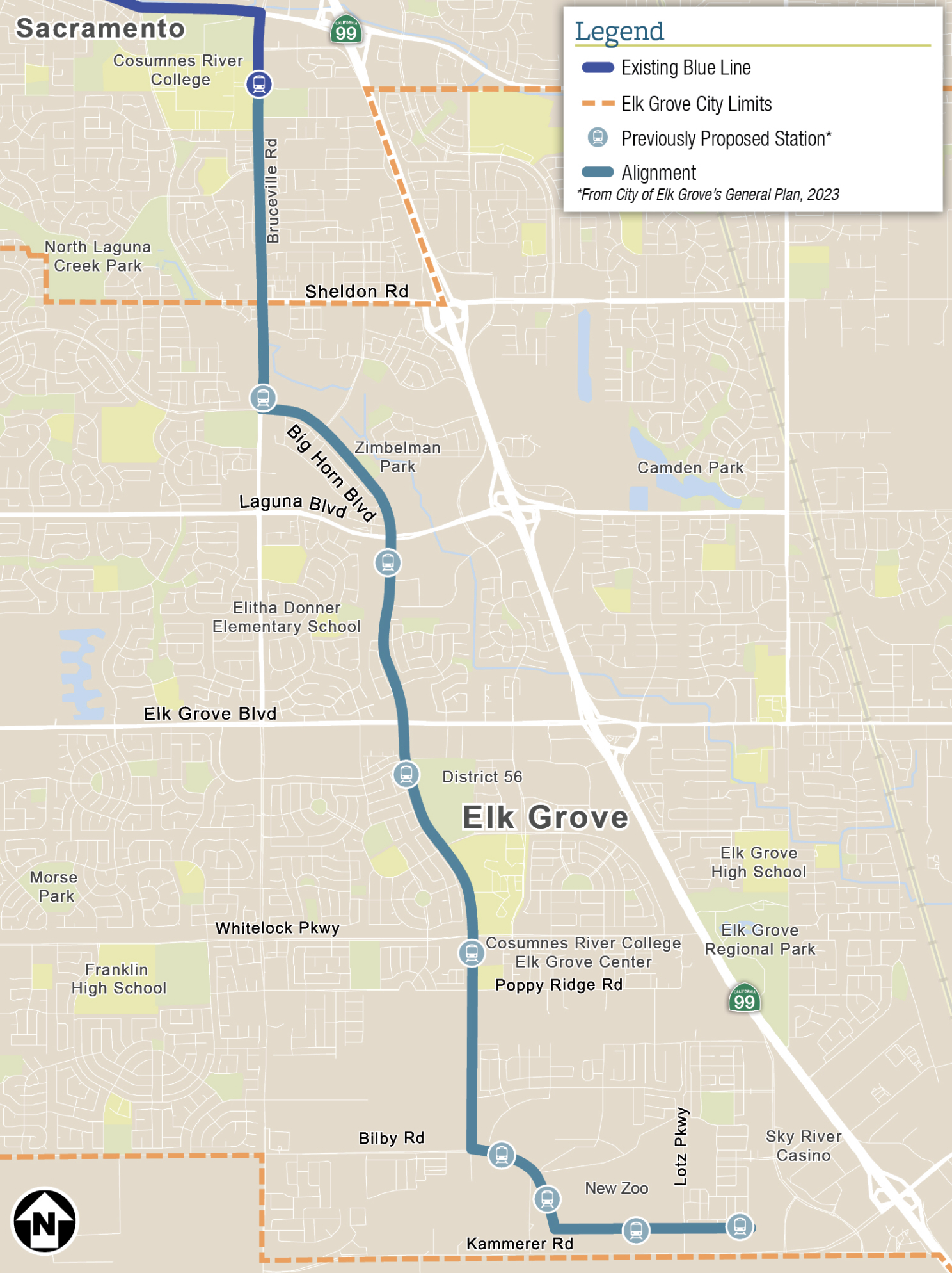
The City of Elk Grove, in partnership with Sacramento Regional Transit District (SacRT), is working to increase mobility options for residents and visitors. The City is exploring providing high-frequency transit service to connect Elk Grove to the larger Sacramento region. The Blue Line/Bus Rapid Transit to Elk Grove Implementation Plan (Project) will study the feasibility of two high-capacity transit alternatives – light rail (LRT) and bus rapid transit (BRT) – to improve travel options for Elk Grove residents and visitors. The project corridor consists of Bruceville Road and Big Horn Boulevard between the current Blue Line terminus at Cosumnes River College and the area near Kammerer Road and State Route 99. The goal is to determine which, if any, transit mode can move forward in the near-term and what the long-term vision is for transit on this corridor.
The City and its partner, the SacRT, were awarded a grant from the State of California to fund this phase of the Project. Other agency stakeholders include the Sacramento Area Council of Governments (SACOG), the City of Sacramento, the County of Sacramento, and the California Department of Transportation (Caltrans). This effort will engage the community throughout the development of the alignment and station locations, station area plans, and a funding strategy.
The first round of outreach includes a survey open until November 30th!
Project Objectives
This Project aims to deliver the following objectives:
-
Sustainability:
Promote safe, reliable and efficient mobility solutions that reduce traffic congestion, greenhouse gas emissions, and vehicle miles traveled -
Accessibility:
Increase access to the regional transportation system for all, including seniors and people with disabilities -
Economic Vitality:
Spur economic development through transit-oriented development at stations along the corridor -
Social Equity:
Prioritize the needs of underserved communities and encourage meaningful public engagement in the transportation decision-making process

Project Background
The City has evaluated transit alternatives for this corridor over the last 20 years. In that time, the Blue Line has been extended to Cosumnes River College, SacRT began operating Elk Grove’s transit service, the area’s population and employment has continued to rapidly grow, the Sacramento Zoo relocating to Elk Grove is advancing, and policy requirements have changed. New and future development along the corridor, such as the Sky River Casino and the New Zoo, will be considered in the analysis. Current technical analysis, modeling, conceptual design, and community feedback will assess opportunities to move this Project towards implementation.
Previous Studies
Planning efforts on the Blue Line extension began with the 2009 Fixed Transit Alignment Study for Corridor Preservation (2009 Study) to determine the right-of-way necessary for a future light rail extension into the City. The 2009 Study proposed an alignment that would bring light rail south from the Cosumnes River College Station through Elk Grove to the City’s southern edge, connecting to major future development areas.
In 2016, the City conducted a Conceptual Layout effort for the proposed alignment to identify a general cross-section for one segment based on SacRT design standards for station and track spacing. This effort considered existing land-use and policy requirements identified in the 2009 Study and used community input received to help shape the conceptual design.
Additionally, in 2019 while Elk Grove ran its own bus system, the City prepared a bus rapid transit study focused on improving the existing Route 110 which runs along the Big Horn Blvd corridor, similar to the proposed light rail alignment. Short-term and long-term BRT elements were analyzed.
Current Phase
The City is undertaking a feasibility study that will confirm the high-capacity transit alignment, identify station locations, forecast ridership potential, and estimate project cost. It will also identify steps and timeline to being able to advance the project to construction. The project will include two rounds of community engagement to inform project outcomes. The project will conclude by Spring 2026.
Community engagement opportunities, which include surveys and pop-ups, are planned to begin later this fall. Sign up for updates!
Schedule
-
July - September 2024Collect data and evaluate existing conditions
-
September - March 2024-2025Develop design concepts and station locations. Evaluate ridership and traffic.
-
October - November 2024Community Engagement: Round 1
-
January - April 2025Develop station area vision plans. Prepare cost estimates.
-
May - June 2025Community Engagement: Round 2
-
July - August 2025Refine station locations and design concepts. Develop funding strategy.
-
July - December 2025Prepare final report and presentations.
-
December 2025Elk Grove City Council Approves Recommendation

